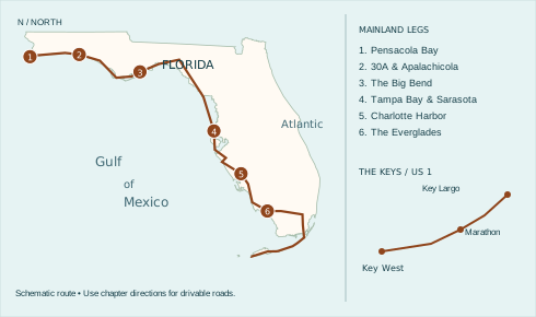
Perdido Key to the Gulf islands, across the Everglades and down to Key West.
Start with the dunes at the Alabama line. Follow the coast past a working letterpress and an oyster-country raw bar, turn out to Cedar Key and cross the sawgrass before the first Keys bridge.
Printing just the driving guide? Choose pages 1–16. The beach index follows.
Plan the drive
Start at Perdido Key. Allow about 10–14 days for this suggested pace. Each chapter can also be a weekend trip. Stop times, bridge traffic and weather can change a day’s plans.
North is up. The dotted line shows the order of the trip. Follow the written road directions around inlets and marshes. Choose a leg or county to separate nearby markers.
Dark green squares mark suggested free breaks. Brown dots mark the other featured stops. Green dots mark beaches with recorded free admission. Blue dots mark other entrances.
Public parks and museums keep their own hours. Check the posted lot and pier prices separately from admission. Park once and walk between nearby stops where possible.
Atlantic side trip · Volusia beach costs
For an Atlantic side trip from the Gulf route, choose where to leave the car before you turn off A1A. Public beach walk-ons are generally free. Federal admission, city meters, county lots and beach driving each have their own terms.
North Peninsula State Park — For a free stop on A1A, park at the Highbridge beach access and walk to the coquina sand. The state park charges no fee.
Sun Splash Park, Daytona Beach — Walk onto the beach for $0. The signed county lot costs visitors $20/day or $100/year. Registered Volusia residents park free.
International Speedway Boulevard — To park on the sand, enter at an open vehicle ramp. Visitors pay $30/day or $150/year. Registered Volusia residents drive free. Check tide, four-wheel-drive and one-way restrictions before turning off A1A.
Main Street Pier, Daytona Beach — For a short walk, the city lists the Breakers Oceanfront Park meters at $1.25/hour. Check the rate on the meter when you arrive.
Flagler Avenue Boardwalk, New Smyrna Beach — The city lot costs $20/day, 9 a.m.–5 p.m. Through December 2026, residents need the city permit. From January 1, 2027, ParkVolusia resident and annual visitor off-beach permits cover seven participating city lots.
Lighthouse Point and Smyrna Dunes — These two inlet parks charge $10 per vehicle or $20 for an annual inlet pass, plus applicable tax and card fees. The county lists no pedestrian charge.
Apollo Beach, Canaveral National Seashore — Park in the numbered lots and cross the dune on foot. Seven days cost $25 per car including passengers, or $15 per person age 16+ arriving on foot or bicycle. Under 16 is free.
The county lists construction at Silver Beach Avenue and the El Portal vehicle ramp. For the closed Mallard, Heron and Egret walkovers, use Marcelle Avenue or Toronita Beach Park. County construction updates.
Eligible residents and visitors with verified disability parking documentation qualify for no-cost county parking, driving and inlet park entry. County fees and registration.
Cocoa Beach city spaces — Marked city spaces cost $6/hour or $25/day, 7 a.m.–7 p.m. The app adds $0.35. California Avenue and Minutemen have no spaces at the crossover.
Jetty Park — Walk or bike in for $0. A vehicle day pass is $15 plus tax ($12 military). Buy it online before arriving.
Playalinda — Seven days cost $25 per car, passengers included. On foot or by bike, pay $15 per person age 16 and up. Children under 16 enter free.
Satellite Beach city lots — Pay $3.50/hour or $15/day, 7 a.m.–7 p.m. Nonresidents can register at least 72 hours ahead for free parking at Pelican and Hightower East.
Indian Harbour Beach — At Millennium and Bicentennial, nonresidents pay $3/hour or $15/day plus tax and applicable fees, 6 a.m.–10 p.m. Registered city residents park free.
Indialantic and Melbourne Beach — Allow $3.50/hour at Nance Park’s town meters or at Ocean Park in Melbourne Beach. Spessard Holland’s county lots have free parking.
Sebastian Inlet State Park — Walk or bike in for $2. A car costs $4 with one person or $8 with two to eight.
Rates checked November 16, 2026. Each beach page links to its sources.
Sunset Coast · Leg 1
Perdido Key to Okaloosa Island
Driving route. Start near the Alabama line on Perdido Key Drive (SR 292). Head through Pensacola on the mainland and across Pensacola Bay on US 98. Use the Pensacola Beach bridge for the island. Fort Pickens is a westbound spur with the same road back. When open, the island road east to Navarre Beach gives you long Gulf views. Return to US 98 at Navarre or Gulf Breeze to reach Okaloosa Island.
Allow a day or two. Check Gulf Islands road alerts before committing to the island route.
State records free entry and parking · portable restrooms
Begin the Sunset Coast near the Alabama line, with the Gulf in front of you before the road swings inland. Access #4 has a short boardwalk from a paved lot to the sand. This small public opening is an easy landmark to miss between developed stretches of Perdido Key.
The state records no entrance or parking fee here, and the local visitor bureau lists portable restrooms. Stop for a few minutes before the Pensacola leg or spend the first evening watching the western sky. Use posted access signs if storm conditions have changed the approach.
Photo stop. Start with the boardwalk disappearing into the dune grass, then walk through for the wide Gulf view.
National seashore admission · check road conditions
At the western end of Santa Rosa Island, Fort Pickens guarded the entrance to Pensacola Bay. The long approach across sand makes its thick brick walls seem even more improbable. Walk into the casemates to see how the shape of one room repeats through the fort.
This is an out-and-back drive from Pensacola Beach. Check National Park Service road alerts before committing to the island’s western end. Take your time on the return: sand can cross the road after high wind, and the dunes are protected.
Photo stop. Frame a brick arch and its shadow from the visitor route. The geometry works even in harsh midday light.
1400 Fort Pickens Road, Pensacola Beach · Map this stop
The Gulfarium’s Dolphin Oasis opened in 2024 on Okaloosa Island. Its interconnected habitats give visitors more than one vantage point, including underwater windows. Look at how a dolphin turns and changes depth as it crosses the glass.
Admission and any booked animal encounter are different purchases. Check the presentation times on arrival before deciding how to spend the rest of the day. US 98 continues east here, so the stop fits without an inland diversion.
Photo stop. Use the viewing glass for a water-level portrait. Stand slightly to one side to reduce your reflection.
1010 Miracle Strip Parkway SE, Fort Walton Beach · Map this stop
Sunset Coast · Leg 2
Scenic 30A to Apalachicola Bay
Driving route. Leave US 98 for Walton County Scenic Highway 30A. Return to US 98 near Inlet Beach. Front Beach Road gives access to Panama City Beach before you cross to St. Andrews in Panama City. Continue through Mexico Beach and Port St. Joe. Gulf County’s CR 30A is a different road. Use it for Indian Pass, then return to US 98 for Apalachicola and Eastpoint.
Plan two daylight drives. Use the paved access at Ed Walline for a beach break.
At the junction of County Road 393 and Scenic 30A, Ed Walline offers something a narrow neighborhood walkover cannot: room to stop, find a restroom and see the beach from above. From that height the water’s bands of color are easier to see.
Use the signed public access and keep the walkover clear. If the lot is full, follow Walton County’s public parking and shuttle information. The businesses across 30A have their own lots.
Photo stop. Shoot the line where the beach meets the water from the elevated viewing area.
4447 W Scenic Highway 30A, Santa Rosa Beach, FL 32459 · Map this stop
On Beck Avenue in historic St. Andrews, a former printing shop keeps the tools of a waterfront newspaper town in view. A composing stick or a drawer of metal type makes the work understandable: each line had to be built before a single page could be printed.
See whether a demonstration is scheduled. The presses and printed pieces give this stop a different rhythm from an afternoon on the sand. Use the St. Andrews address in Panama City; it is across the bay from Panama City Beach.
Photo stop. Ask to photograph a press or a tray of type. Individual metal letters make a good close-up.
1134 Beck Ave Panama City, Florida 32401 · Map this stop
Near Indian Pass, a seafood stop on County Road 30A breaks up the long sweep around St. Joseph Bay. At the raw bar, ask what oysters are on offer and where they were harvested. Availability changes, and the answer is part of the meal.
The Gulf County road here shares its number with Walton County’s Scenic 30A, well to the west. Select the Port St. Joe address when navigating. Check hours before taking the coastal diversion and return to US 98 for Apalachicola.
Photo stop. The roadside sign and low building make a better record of this stop than a distant picture of the water.
8391 County Road 30A Port St. Joe, Florida 32456 · Map this stop
In Eastpoint, fresh river water meets the salt water of Apalachicola Bay. The reserve’s tanks and exhibits make the gradual change between the two visible. This is a good place to understand the oyster country you have just driven through before crossing another bridge.
The nature center is on Island Drive, on the approach toward St. George Island. Use the exhibits and trails as time allows. A bridge trip to the island is a separate out-and-back; US 98 continues east on the mainland toward Carrabelle.
Photo stop. Use the boardwalk to frame the transition between the trees and open marsh.
108 Island Drive Eastpoint, Florida 32328 · Map this stop
Sunset Coast · Leg 3
Carrabelle to Cedar Key
Driving route. Follow US 98 east and south through the Big Bend. Reach St. Marks Lighthouse by turning south onto Lighthouse Road (CR 59), then retrace the spur. At Perry the FDOT rest area is about five miles north on US 19/27. The main drive turns south. Stay on US 19/98 through the coastal plain. At Otter Creek, SR 24 runs out to Cedar Key and back. Marshes and rivers keep the through-road inland.
Fuel in town before the refuge. Give Cedar Key its own afternoon rather than treating it as a quick pass-through.
Fishing, boatbuilding and wartime training all left traces in Carrabelle. The town museum gathers objects and photographs that would otherwise be scattered among families. Give a single early waterfront picture a close look before comparing it with the riverfront outside.
The museum occupies the former City Hall. Check its limited opening days, especially early in the week. It makes a good indoor break on a day otherwise spent following US 98 between the water and the pines.
Photo stop. Ask about photographing the local objects in the collection; choose one that tells a boatbuilding story.
106 SE Ave B Carrabelle, Florida 32322 · Map this stop
At the end of Lighthouse Road, salt marsh opens onto Apalachee Bay. The white lighthouse marks an old approach to the St. Marks River. Look along the water’s edge for wading birds before moving on to the tower; the landscape explains why the light is here.
Enter through the St. Marks National Wildlife Refuge and return along the same road. Grounds access and tower access are separate. Take water and allow time for the full round trip to US 98 rather than treating the lighthouse as a quick turnoff.
Photo stop. From an established viewing spot, put the lighthouse behind the marsh grass rather than centering it alone.
Lighthouse Road at Apalachee Bay, St. Marks, FL 32355 · Map this stop
On US 19/27 north of Perry there is a genuine state highway rest area, unusual on a route that spends so little time on interstates. It offers a dependable place to get out of the car between long runs of pinewoods and two-lane side roads.
The stop is north of Perry, so it is a short backtrack if you have come into town from the west on US 98. Follow the rest-area signs. Check FDOT’s facility map for service changes before counting on any single stop.
Photo stop. Save the camera for the picnic area. The main reason to pull in here is a real break from driving.
US 19 and US 27 north of Perry, Perry, FL 32347 · Map this stop
Cedar Key sits at the end of State Road 24, well off the through highway. The municipal pier on Dock Street puts you on the waterfront with views of low islands and working boats. A short walk here makes the long mainland approach feel very far away.
Use the downtown Dock Street location, which is distinct from the Number Four Bridge fishing site outside town. Walk out as far as posted conditions allow, then return on SR 24. There is no coast road from Cedar Key to Crystal River.
Photo stop. From Dock Street, catch the rail leading out toward the low islands. Keep fishing lines out of your way.
550 Dock Street Cedar Key, Florida 32625 · Map this stop
Sunset Coast · Leg 4
Tarpon Springs to Siesta Key
Driving route. Take US 19 south via Crystal River to Tarpon Springs. For a Pinellas barrier-island drive, join Gulf Boulevard near Indian Rocks Beach and follow it south toward St. Pete Beach. Fort De Soto is a round trip via the Pinellas Bayway. Return to I-275 and cross the tolled Sunshine Skyway to reach the Bradenton side. Follow US 41 toward Sarasota. Mote SEA is an inland side trip near I-75. Use a Siesta Key causeway to regain the sand.
Budget for tolls and park parking. Save the long sunset stop for the free county lot at Siesta Beach.
Shopping stop · tours and cruises priced separately
At the sponge docks in Tarpon Springs, natural sponges make the history tactile. Different forms suit different uses, and a shop counter is a good place to ask which varieties come from local waters. Greek diving families helped shape the waterfront around this trade.
Find the shop on Dodecanese Boulevard and park once to explore on foot. A cruise and a walk along the docks are different ways to spend the afternoon. Keep working docks clear when boats are loading.
Photo stop. Look for the texture of uncut sponges. Ask before arranging or photographing stock.
510 Dodecanese Blvd Tarpon Springs, Florida 34689 · Map this stop
At the end of the Pinellas Bayway, the low concrete works of Battery Laidley look very different from the brick chambers at Fort Pickens. Both guarded a harbor entrance. Here, the earth-covered battery and heavy mortars show how coastal defense had changed by the turn of the twentieth century.
Follow the historic-fort signs within the county park. Pier, boardwalk and fort access can change independently during repairs. Return across the causeway when finished. The road does not continue south from the fort to Sarasota.
Photo stop. From a permitted upper viewpoint, include the old battery and the open Gulf in one frame.
3500 Pinellas Bayway S, Tierra Verde. Follow signs to the historic fort on Mullet Key · Map this stop
Mote opened its new Science Education Aquarium in October 2025 beside Nathan Benderson Park. This is an intentional inland break from the barrier islands. The exhibits connect what you see underwater with questions scientists are studying in Florida’s waters.
Navigate to 225 University Town Center Drive. Mote’s research and aquarium sites have different addresses, a useful distinction for anyone following an older guide. Reserve entry ahead if the aquarium is the centerpiece of your Sarasota day.
Photo stop. Shoot through an exhibit window with the lens close to the glass and follow staff guidance on flash.
225 University Town Center Drive, Sarasota · Map this stop
Siesta’s wide band of pale quartz sand leaves a long approach between the pavilion and the water. That distance is part of the experience: the sound changes from conversations at the lot to the wash of the Gulf. There is plenty to see simply walking the public shore.
Use the main county beach at 948 Beach Road for parking, restrooms and access facilities. The free lot can fill. For sunset, arrive well before the light changes and note which access you used for the walk back.
Photo stop. From the public sand, let a lifeguard stand or a set of footprints give the expanse some scale.
Driving route. Continue south through Venice on US 41. Roads to outer-island beaches are side trips with a return to the mainland. Cross Charlotte Harbor to Punta Gorda, then follow US 41 to the Caloosahatchee and Fort Myers. Take McGregor Boulevard for the historic estates and rejoin the southbound route to Naples.
On a two-day leg, spend one evening at Charlotte Harbor and the next morning in the gardens.
Punta Gorda faces Charlotte Harbor rather than the open Gulf. At Fishermen’s Village the covered promenade, shops and marina put the harbor in view even when the weather is changeable. It is a useful change of pace after the long open beaches of Sarasota County.
Pick a meal or simply take time to look across the water before continuing south. Check parking arrangements and business hours before an evening visit. The historic center of Punta Gorda is a short drive back toward US 41.
Photo stop. From a public walkway, use the marina pilings to frame Charlotte Harbor.
1200 West Retta Esplanade Punta Gorda, Florida 33950 · Map this stop
Along the Caloosahatchee River, Thomas Edison and Henry Ford spent winters on neighboring properties. The gardens and laboratory explain why plants mattered to an inventor: Edison researched domestic sources of rubber. The riverside setting explains why Fort Myers appealed as a retreat.
Give the laboratory and museum time as well as the houses. The river is west of the main highway here. You can visit without making the much longer out-and-back drive onto the barrier islands.
Photo stop. Frame a garden path or the spreading banyan from the visitor walkway. Ask about indoor photography.
Plants from tropical regions around the world grow in this garden just south of central Naples. Walk slowly enough to compare leaves, bark and the ways plants handle heat and water. The garden introduces the shift from Gulf beach towns to the wetlands farther east.
Go early for gentler light, bring water and check the garden’s hours before making it the last stop of the day. Return to US 41 east for the Tamiami Trail crossing. There is no beachfront highway through the Everglades.
Photo stop. Look for a reflection beside a garden water feature. A low angle from the path keeps the background simple.
Driving route. Turn east on US 41, the Tamiami Trail. At SR 29, turn south to Everglades City and back for the town museum. Continue east past Oasis in Big Cypress. Turn south on Krome Avenue (SR 997), then east on Palm Drive to US 1 at Florida City. The mangrove coast has no highway directly to Key West.
Allow daylight for the crossing. Fill the tank and pack water before you leave Naples.
Everglades City was once the headquarters for construction of the Tamiami Trail. A building that served as a laundry now holds the museum. It is an unusually intimate way to see the people and working town behind a road that can look empty from a windshield.
Turn south off US 41 at SR 29, then return the same way to continue east. Check the museum’s opening days. The stop makes a natural pair with the preserve farther on: one shows the people who built the road, the other the country it crosses.
Photo stop. Take an exterior picture of the small former laundry building before looking at the historic photographs inside.
105 West Broadway Avenue Everglades City, Florida 34139 · Map this stop
No preserve entrance fee · check facilities and boardwalk alerts
At Oasis on the Tamiami Trail, the view down into the roadside canal can be more revealing than the view across the forest. Watch the bank and the surface for alligators, turtles and wading birds. A few quiet minutes usually reveal more than a quick photograph.
Big Cypress has no entrance fee. Check National Park Service notices for visitor-center hours, boardwalk access and restroom availability before relying on the stop. After Oasis, continue east to the mainland connection for US 1 and the Keys.
Photo stop. From the open public observation area, frame a reflection or an alligator at a distance. Stay behind the rail.
Driving route. Both drives now take US 1, the Overseas Highway, south from Florida City. Mile markers count down toward Key West. Stop in Key Largo, continue to Islamorada and then to Anne’s Beach near MM 73.5. Bay and ocean can be on opposite sides of the same narrow island.
Give this leg a day if you want a museum visit and a long lunch. Look for designated parking before turning.
At the upper end of the Keys, the Conch House is a good place to get out of traffic and sit down before the island drive. Its garden setting offers a quieter introduction than rushing straight to the next bridge. Ask what seafood the kitchen is serving today.
The address is on the Overseas Highway in Key Largo. Give the entrance your attention in advance; U-turns and last-minute stops are a poor way to find a restaurant on this road. Check service times before building a meal around the stop.
Photo stop. Use the garden setting or porch for a picture with your traveling companions before the food arrives.
Long before modern scuba equipment, working underwater could mean carrying a metal helmet and depending on air from the surface. This Islamorada museum follows the problem of breathing underwater through a remarkable range of suits, helmets and apparatus.
Look for design changes that solved one problem while creating another, such as weight or mobility. It is an indoor stop on US 1, which makes it easy to fit between beach breaks or move to a rainy part of the day.
Photo stop. Compare the shapes of diving helmets in one frame where indoor photographs are allowed.
82990 Overseas Highway Islamorada, Florida 33036 · Map this stop
On Lower Matecumbe Key, the water stays shallow for a long distance and the mangroves come close to the road. A boardwalk connects small pockets of shore and picnic space. This feels very different from an Atlantic surf beach, especially when the tide leaves little exposed sand.
Use the designated parking areas at mile marker 73.5 on the oceanside. The north end has the restroom. If the lot is full, continue to another stop. The Overseas Highway shoulder is not a substitute for a parking space.
Photo stop. From the boardwalk, frame the mangroves against the pale shallows. Low tide changes the picture.
Overseas Highway at mile marker 73.5, Islamorada, FL 33036 · Map this stop
Florida Keys · Leg 2
Marathon to Big Pine Key
Driving route. Follow US 1 through Marathon. Stop at the Turtle Hospital and the Marathon end of the Old Seven Mile Bridge before taking the modern highway bridge. Continue to Big Pine Key. Turn north onto Key Deer Boulevard for the Blue Hole, then retrace the detour to US 1.
Park before taking bridge photographs. Drive slowly on Big Pine Key and watch for Key deer, particularly at dusk.
In Marathon, an old motel became a hospital for injured sea turtles. The guided visit gives the rehabilitation pools a purpose beyond viewing wildlife: each animal is here for care, and the goal for releasable patients is a return to the sea.
Reserve a tour time before building the rest of your day around it. Current patients and care needs determine what visitors see. This stop and the old bridge are close enough to do together without another long run along US 1.
Photo stop. Ask the guide where photographs are permitted. Give recovering animals space and skip the flash.
2396 Overseas Highway Marathon, Florida 33050 · Map this stop
Island visit ticketed · old bridge walk is separate
Pigeon Key housed workers who helped build Henry Flagler’s Overseas Railway. From the old Seven Mile Bridge the island looks small enough to miss, which makes the scale of the bridge work more striking. A visit brings the workers’ buildings and the railway story together.
Use the official visitor center for island tickets and the departure point. A walk on the publicly accessible stretch of old bridge is a different outing. Park on the Marathon end, check access and take water; the exposed bridge has little shade.
Photo stop. From the pedestrian bridge, put the old rail alignment and the newer highway bridge in the same view.
1090 Overseas Highway Marathon, Florida 33050 · Map this stop
North of US 1 on Big Pine Key, a former quarry holds an unexpected patch of freshwater habitat. The Blue Hole observation platform lets you look for turtles, birds or an alligator without walking to the water’s edge. A wildlife sighting is never guaranteed.
Follow Key Deer Boulevard for roughly three miles from US 1 and slow down throughout the refuge. Small Key deer can appear at the roadside. Use the platform and designated parking; give animals room and keep food in the car.
Photo stop. From the observation platform, photograph the water framed by limestone and vegetation. Give wildlife the right of way.
Key Deer Boulevard, Blue Hole observation trail, Big Pine Key, FL 33043 · Map this stop
Florida Keys · Leg 3
The Lower Keys to Mile Zero
Driving route. Continue west on US 1 through the Lower Keys. Follow the signs for US 1 into Key West, park once in Old Town and finish on foot. The lighthouse is on Whitehead Street. The END US 1 sign stands at Whitehead and Fleming streets.
Give Old Town an unhurried half day. The lighthouse and road sign make a walkable last pair of stops.
After following lighthouses down the coast, finish with a tower that stands among the roofs of Old Town. Key West’s light and keepers’ quarters tell the story of the people who maintained a warning system for ships approaching the reefs.
Visit the quarters even if you skip the climb. From here, leave the car parked and walk along Whitehead Street toward the end of US 1. The short walk connects a seafarer’s landmark with a modern road traveler’s one.
Photo stop. From the grounds, put palms around the tower. From the top, look for the line between rooftops and open water.
938 Whitehead Street Key West, Florida 33040 · Map this stop
Both coast routes finish at the corner of Fleming and Whitehead streets. After the bridges and open water of the Keys, the road ends at an ordinary city intersection. That contrast is the pleasure of the last photograph: a green road sign can stand for the whole trip.
Park legally and walk to the sign. Check which direction the sign faces before composing your shot and stay on the sidewalk. If you are traveling with someone, trade cameras here so each of you goes home with a finish-line picture.
Photo stop. Stand on the sidewalk at Whitehead and Fleming and get the END US 1 sign in the frame. Let traffic pass.
Whitehead Street at Fleming Street, Key West, FL 33040 · Map this stop
Beach entrances along this coast
924 Florida DEP access points across the route counties, including the Keys. Open a county to find the street, entrance map and listed facilities. Some island and marsh locations require a boat. A public access point can be a viewpoint or walkover. Follow posted restrictions.
Beach facilities and access classifications come from Florida DEP. Fees are marked only when stated by the inventory or an operator. Use the directory profiles for current operator hours and tickets.