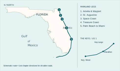
Amelia Island to the Atlantic beaches, then the Overseas Highway to Key West.
Trace the Atlantic through the marshes of Fort George Island, a shipwreck keepers’ station and the dunes of Cocoa Beach. Save room for the seafood counter, the launch gantry and an ocean sunrise.
Printing just the driving guide? Choose pages 1–14. The beach index follows.
Plan the drive
Start at Fernandina Beach. Allow about 7–10 days for this suggested pace. Each chapter can also be a weekend trip. Stop times, bridge traffic and weather can change a day’s plans.
North is up. The dotted line shows the order of the trip. Follow the written road directions around inlets and marshes. Choose a leg or county to separate nearby markers.
Dark green squares mark suggested free breaks. Brown dots mark the other featured stops. Green dots mark beaches with recorded free admission. Blue dots mark other entrances.
Public parks and museums keep their own hours. Check the posted lot and pier prices separately from admission. Park once and walk between nearby stops where possible.
Volusia beach costs
On the Atlantic route, choose where to leave the car before you turn off A1A. Public beach walk-ons are generally free. Federal admission, city meters, county lots and beach driving each have their own terms.
North Peninsula State Park — For a free stop on A1A, park at the Highbridge beach access and walk to the coquina sand. The state park charges no fee.
Sun Splash Park, Daytona Beach — Walk onto the beach for $0. The signed county lot costs visitors $20/day or $100/year. Registered Volusia residents park free.
International Speedway Boulevard — To park on the sand, enter at an open vehicle ramp. Visitors pay $30/day or $150/year. Registered Volusia residents drive free. Check tide, four-wheel-drive and one-way restrictions before turning off A1A.
Main Street Pier, Daytona Beach — For a short walk, the city lists the Breakers Oceanfront Park meters at $1.25/hour. Check the rate on the meter when you arrive.
Flagler Avenue Boardwalk, New Smyrna Beach — The city lot costs $20/day, 9 a.m.–5 p.m. Through December 2026, residents need the city permit. From January 1, 2027, ParkVolusia resident and annual visitor off-beach permits cover seven participating city lots.
Lighthouse Point and Smyrna Dunes — These two inlet parks charge $10 per vehicle or $20 for an annual inlet pass, plus applicable tax and card fees. The county lists no pedestrian charge.
Apollo Beach, Canaveral National Seashore — Park in the numbered lots and cross the dune on foot. Seven days cost $25 per car including passengers, or $15 per person age 16+ arriving on foot or bicycle. Under 16 is free.
The county lists construction at Silver Beach Avenue and the El Portal vehicle ramp. For the closed Mallard, Heron and Egret walkovers, use Marcelle Avenue or Toronita Beach Park. County construction updates.
Eligible residents and visitors with verified disability parking documentation qualify for no-cost county parking, driving and inlet park entry. County fees and registration.
Cocoa Beach city spaces — Marked city spaces cost $6/hour or $25/day, 7 a.m.–7 p.m. The app adds $0.35. California Avenue and Minutemen have no spaces at the crossover.
Jetty Park — Walk or bike in for $0. A vehicle day pass is $15 plus tax ($12 military). Buy it online before arriving.
Playalinda — Seven days cost $25 per car, passengers included. On foot or by bike, pay $15 per person age 16 and up. Children under 16 enter free.
Satellite Beach city lots — Pay $3.50/hour or $15/day, 7 a.m.–7 p.m. Nonresidents can register at least 72 hours ahead for free parking at Pelican and Hightower East.
Indian Harbour Beach — At Millennium and Bicentennial, nonresidents pay $3/hour or $15/day plus tax and applicable fees, 6 a.m.–10 p.m. Registered city residents park free.
Indialantic and Melbourne Beach — Allow $3.50/hour at Nance Park’s town meters or at Ocean Park in Melbourne Beach. Spessard Holland’s county lots have free parking.
Sebastian Inlet State Park — Walk or bike in for $2. A car costs $4 with one person or $8 with two to eight.
Rates checked November 16, 2026. Each beach page links to its sources.
Sunrise Coast · Leg 1
Amelia Island to Mayport
Driving route. Begin in Fernandina Beach. Head east to the ocean, then take A1A south via American Beach, the Nassau Sound bridge and the marsh islands. Kingsley Plantation is a side trip on Fort George Island. The St. Johns River Ferry carries vehicles for a fare. If it is out of service, use Heckscher Drive to I-295 over the Dames Point Bridge, then return east toward the beaches on Atlantic Boulevard.
Allow a day for the museum, plantation and ferry. Carry a picnic for the crossing.
Start a few blocks off the Amelia River, in Fernandina’s old port town. A basket of shrimp makes more sense here than a long lunch on the highway. Timoti’s lets a group order at the counter, settle outside and take its time over the first meal of the trip.
Look at the catch and preparation choices before ordering. Save the beach for after lunch: from downtown, head east across the island, then turn south on the coastal side. The riverfront you started on and the Atlantic shore are two different sides of Amelia.
Photo stop. Frame the cottages along North Third Street from the sidewalk.
21 North 3rd Street Fernandina Beach, Florida 32034 · Map this stop
In 1935, Abraham Lincoln Lewis and the Afro-American Life Insurance Company helped create American Beach as an ocean resort for Black families during segregation. At the museum on Julia Street, the story moves from the people who vacationed here to those who fought to keep their community intact.
Allow time for MaVynee Betsch’s part of the story. Known as the Beach Lady, she spent decades preserving the place her great-grandfather helped establish. Look at the museum hours before leaving Fernandina. The surrounding streets are a living residential neighborhood.
Photo stop. Use the museum sign for your location shot. Ask before photographing objects inside.
1600 Julia Street, Fernandina Beach, FL 32034 · Map this stop
On Fort George Island, the arc of former slave cabins comes before the riverfront house. The walls contain oyster shell, a local material used to make tabby. The arrangement of the cabins, work spaces and planter’s house tells you whose labor made a river plantation possible.
Start with the cabin interpretation and give the grounds time on foot. The National Park Service posts access days and building availability separately. Return to the signed highway and check the vehicle ferry before committing to the Mayport crossing.
Photo stop. From the marked path, include several tabby cabin walls in a single frame.
Driving route. From Mayport, follow Mayport Road to Atlantic Boulevard and the beach towns. Continue south on A1A through Ponte Vedra Beach and Vilano Beach. Cross the Vilano bridge into St. Augustine. Leave downtown by the Bridge of Lions and follow A1A down Anastasia Island to Fort Matanzas.
Save a half day for St. Augustine on foot. Take the free Fort Matanzas ferry when it is operating.
A narrow piece of barrier island separates the Atlantic from the Intracoastal Waterway north of Vilano. At Mussallem, leave the busy Coastal Highway and follow the beach access to the water. This is an easy place to put down a phone, take off your shoes and hear the surf.
St. Johns County lists parking and a restroom. Use the signed parking area and the designated crossing or walkover. On a multi-stop day, this is the beach break to take before heading over the bridge toward the streets of St. Augustine.
Photo stop. Photograph the first sight of the horizon from the walkover, leaving the dune vegetation untouched.
3350 Coastal Highway, St. Augustine, FL 32084 · Map this stop
From the inlet, the fort looks low and deliberate. Its coquina walls are made of tiny shell fragments, and its projecting bastions gave defenders a view along each face. Walking the waterfront first makes the fort’s position at the entrance to Spanish St. Augustine much easier to read.
An entrance ticket takes you inside the fort. Leave time for the upper gun deck when it is accessible, then return to town on foot. Downtown parking is separate. For the next coastal stretch, cross the Bridge of Lions toward Anastasia Island.
Photo stop. Stand on the public bayfront for the stone bastions; include the waterline for scale.
11 South Castillo Drive, St. Augustine · Map this stop
There are two very different forts on this stretch. Here a small outpost guarded the southern water approach to St. Augustine. The river crossing explains its purpose in a way a roadside view cannot: the tower sits across the water on Rattlesnake Island.
Pick up a free boarding pass at the visitor area when the National Park Service ferry is running. Space is limited and weather can interrupt service. The mainland grounds make a worthwhile break even if the boat is full. This passenger ferry does not carry your car.
Photo stop. Photograph the low watchtower across the Matanzas River or from the passenger ferry.
Visitor center and ferry pickup, 8635 A1A South, St. Augustine · Map this stop
Sunrise Coast · Leg 3
Flagler Beach to the Space Coast
Driving route. Keep A1A through Flagler Beach and the Daytona area. Ponce Inlet is an out-and-back from Dunlawton Avenue. Return west on Dunlawton to US 1. New Smyrna Beach and the Apollo side of Canaveral National Seashore are optional coastal spurs. No public through-road crosses the seashore. Take US 1 to Titusville and SR 405 for Kennedy Space Center. Leave via SR 3 and SR 528 toward Cape Canaveral.
Allow most of a day for the visitor complex. Make the lighthouse a separate morning.
Flagler Beach is a good place to stop letting the road choose your meals. This seafood restaurant also operates a fish market, so a group can sit down to eat or pick out something for a kitchen farther along the trip. Ask what is available that day.
Use the South Ocean Shore Boulevard address on the listing. Older recommendations may send you to the former downtown location. After lunch, use a signed public beach crossing for a look back at the low-rise town from the ocean side.
Photo stop. Use the oceanfront streetscape for your picture and keep the restaurant entrance clear.
1224 South Ocean Shore Boulevard Flagler Beach, Florida 32136 · Map this stop
At the southern tip of the Daytona barrier island, a red brick tower rises over the former keepers’ quarters. The museum’s lenses make the light itself worth understanding: glass prisms turn a small source into a beam strong enough to guide a ship.
Allow a longer stop if you plan to climb. The keepers’ buildings give nonclimbers a visit of their own. Ponce Inlet ends the ocean road here. Drive back north to a mainland bridge before continuing toward New Smyrna Beach.
Photo stop. From ground level, set the red tower against the keepers’ buildings. You can get the shot without climbing.
4931 South Peninsula Drive Ponce Inlet, Florida 32127 · Map this stop
The Gantry at LC-39 opened to visitors in 2025. It adds a view of the launch complex to a museum day that can otherwise be spent looking up at rockets indoors. From the observation level, the flat marsh and the distant launch structures belong in the same photograph.
Reach the Gantry on the visitor complex’s bus tour. There is no public drive through the launch pads to Cocoa Beach. Budget most of a day if you want the bus and the main exhibits, and check for launch-related changes before setting out.
Photo stop. At the Gantry, use the marked observation area to put the launch landscape behind you.
Guest entrance on Space Commerce Way, Merritt Island · Map this stop
Sunrise Coast · Leg 4
Cocoa Beach to Hutchinson Island
Driving route. From Cape Canaveral follow A1A through Cocoa Beach, Melbourne Beach and Sebastian Inlet. Reach the Sebastian museum by the Wabasso causeway and US 1, then retrace the spur to A1A. At Fort Pierce Inlet cross the North Causeway to the mainland, take US 1 south and return east on Seaway Drive to South Hutchinson Island. The House of Refuge is on MacArthur Boulevard.
Start at Lori Wilson Park if you want an ocean sunrise and a free county parking lot.
At this Cocoa Beach park, the change from the hotel strip to the ocean happens in a short walk. The dune vegetation holds the foreground while the Atlantic opens in front of you. It is a particularly good stop for a sunrise if the park’s opening hours suit the season.
Use the marked crossovers from the parking area. Restrooms make it a practical pause between the Space Coast and the long barrier-island drive south. Brevard County lists free parking. Leave any dune flowers or nesting areas undisturbed.
Photo stop. From the dune crossover, frame the open water between the plants on either side.
1500 N Atlantic Ave Cocoa Beach, Florida 32931 · Map this stop
In Sebastian, objects recovered from wrecks put the Treasure Coast name in human terms. Coins and cargo were once part of ships, voyages and livelihoods. Look at how a single object was identified and conserved before moving on to the larger displays.
The museum is on mainland US 1. Cross from the barrier island at Wabasso and make the short trip north to the museum, then retrace to return to A1A. It is a sensible weather-day choice when wind makes the beach less inviting.
Photo stop. Choose a close-up of an exhibit detail where photography is permitted. Flash can hide more than it reveals.
1322 US Highway 1 Sebastian, Florida 32958 · Map this stop
Before this coast had a road lined with hotels, a shipwreck survivor might have come ashore here to find shelter and supplies. The House of Refuge on Hutchinson Island preserves that story in a keeper’s home close enough to hear the sea. The Historical Society reopened the house after restoration for its 150th anniversary in 2026.
Make time to look at the rock below the house from a safe overlook. It helps explain why this stretch was dangerous to approach from the water. Leave waves and wet rocks out of your footing, especially when a swell is running.
Photo stop. Use the public approach for a picture of the keeper’s house above the rocky shoreline.
301 SE MacArthur Boulevard Stuart, Florida 34996 · Map this stop
Sunrise Coast · Leg 5
Jupiter to South Beach
Driving route. Leave Hutchinson Island by the Stuart causeways. Use US 1 past inland gaps and pick up signed beach roads in Jupiter and Juno. Singer Island ends at Lake Worth Inlet. Use Blue Heron Boulevard to the mainland, then the Flagler Memorial Bridge for Palm Beach. Follow A1A where signed. There is no car crossing at Port Everglades inlet. Use the mainland connection between SE 17th Street and Dania Beach Boulevard. From South Pointe, turn west over the MacArthur Causeway and join US 1 toward Florida City.
Allow two days to walk the gardens, linger at Manatee Lagoon and reach South Pointe on foot.
Free beach entry and park parking · pier charged separately
At Juno, you can see the length of the pier from the sand without buying a pier ticket. The beach park has restrooms and places to wash off. The open Atlantic horizon makes this an especially good choice for the first light of the day.
Use the county beach parking area and the marked crossing. The pier has its own operator, admission and repair notices. Decide whether you want to walk onto the deck after you have seen the view from shore.
Photo stop. Keep the pier to one side of the frame at sunrise so the horizon stays visible.
14775 U.S. Highway 1 Juno Beach, Florida 33408 · Map this stop
The warm-water outflow beside the power plant draws manatees during cold weather. From the deck you can watch the water change from a dark shape to a back, nostrils and a ripple. On warmer days the exhibits explain the animals even when none come into view.
The center offers free admission and parking. Plan around its opening days and treat a sighting as a possibility. This mainland stop fits between the inlet towns and Palm Beach; stay on the public observation deck.
Photo stop. From the observation deck, wait for a manatee’s nose or the rings it leaves on the surface.
6000 N Flagler Drive West Palm Beach, Florida 33407 · Map this stop
A studio, courtyard and tropical grounds survive just inland from Fort Lauderdale Beach. Bonnet House tells the story of artists Frederic and Evelyn Bartlett through the rooms they lived in and the landscape they kept around them.
Leave time for both the house and the grounds. A short look at the courtyard gives a different sense of the city from the towers visible along A1A. Check entry arrangements before you park, particularly if you want the interior tour.
Photo stop. Look for the garden reflected in the water from a visitor path. Check indoor photography rules.
Miami Beach ends in a park where an oceanside stroll becomes a view down Government Cut. Freighters, tugs and cruise ships can pass close enough to read their names. The promenade works just as well on a quiet day when all you see are the channel markers.
Use the park restrooms and signed beach access, then return to the road for the mainland crossing. The channel has no vehicle crossing here. Photograph from the public path or sand and keep clear of the working waterfront.
Photo stop. From the public promenade, place the ship channel between your camera and the far shore.
1 Washington Avenue, Miami Beach, FL 33139 · Map this stop
Florida Keys · Leg 1
Key Largo to Lower Matecumbe
Driving route. Both drives now take US 1, the Overseas Highway, south from Florida City. Mile markers count down toward Key West. Stop in Key Largo, continue to Islamorada and then to Anne’s Beach near MM 73.5. Bay and ocean can be on opposite sides of the same narrow island.
Give this leg a day if you want a museum visit and a long lunch. Look for designated parking before turning.
At the upper end of the Keys, the Conch House is a good place to get out of traffic and sit down before the island drive. Its garden setting offers a quieter introduction than rushing straight to the next bridge. Ask what seafood the kitchen is serving today.
The address is on the Overseas Highway in Key Largo. Give the entrance your attention in advance; U-turns and last-minute stops are a poor way to find a restaurant on this road. Check service times before building a meal around the stop.
Photo stop. Use the garden setting or porch for a picture with your traveling companions before the food arrives.
Long before modern scuba equipment, working underwater could mean carrying a metal helmet and depending on air from the surface. This Islamorada museum follows the problem of breathing underwater through a remarkable range of suits, helmets and apparatus.
Look for design changes that solved one problem while creating another, such as weight or mobility. It is an indoor stop on US 1, which makes it easy to fit between beach breaks or move to a rainy part of the day.
Photo stop. Compare the shapes of diving helmets in one frame where indoor photographs are allowed.
82990 Overseas Highway Islamorada, Florida 33036 · Map this stop
On Lower Matecumbe Key, the water stays shallow for a long distance and the mangroves come close to the road. A boardwalk connects small pockets of shore and picnic space. This feels very different from an Atlantic surf beach, especially when the tide leaves little exposed sand.
Use the designated parking areas at mile marker 73.5 on the oceanside. The north end has the restroom. If the lot is full, continue to another stop. The Overseas Highway shoulder is not a substitute for a parking space.
Photo stop. From the boardwalk, frame the mangroves against the pale shallows. Low tide changes the picture.
Overseas Highway at mile marker 73.5, Islamorada, FL 33036 · Map this stop
Florida Keys · Leg 2
Marathon to Big Pine Key
Driving route. Follow US 1 through Marathon. Stop at the Turtle Hospital and the Marathon end of the Old Seven Mile Bridge before taking the modern highway bridge. Continue to Big Pine Key. Turn north onto Key Deer Boulevard for the Blue Hole, then retrace the detour to US 1.
Park before taking bridge photographs. Drive slowly on Big Pine Key and watch for Key deer, particularly at dusk.
In Marathon, an old motel became a hospital for injured sea turtles. The guided visit gives the rehabilitation pools a purpose beyond viewing wildlife: each animal is here for care, and the goal for releasable patients is a return to the sea.
Reserve a tour time before building the rest of your day around it. Current patients and care needs determine what visitors see. This stop and the old bridge are close enough to do together without another long run along US 1.
Photo stop. Ask the guide where photographs are permitted. Give recovering animals space and skip the flash.
2396 Overseas Highway Marathon, Florida 33050 · Map this stop
Island visit ticketed · old bridge walk is separate
Pigeon Key housed workers who helped build Henry Flagler’s Overseas Railway. From the old Seven Mile Bridge the island looks small enough to miss, which makes the scale of the bridge work more striking. A visit brings the workers’ buildings and the railway story together.
Use the official visitor center for island tickets and the departure point. A walk on the publicly accessible stretch of old bridge is a different outing. Park on the Marathon end, check access and take water; the exposed bridge has little shade.
Photo stop. From the pedestrian bridge, put the old rail alignment and the newer highway bridge in the same view.
1090 Overseas Highway Marathon, Florida 33050 · Map this stop
North of US 1 on Big Pine Key, a former quarry holds an unexpected patch of freshwater habitat. The Blue Hole observation platform lets you look for turtles, birds or an alligator without walking to the water’s edge. A wildlife sighting is never guaranteed.
Follow Key Deer Boulevard for roughly three miles from US 1 and slow down throughout the refuge. Small Key deer can appear at the roadside. Use the platform and designated parking; give animals room and keep food in the car.
Photo stop. From the observation platform, photograph the water framed by limestone and vegetation. Give wildlife the right of way.
Key Deer Boulevard, Blue Hole observation trail, Big Pine Key, FL 33043 · Map this stop
Florida Keys · Leg 3
The Lower Keys to Mile Zero
Driving route. Continue west on US 1 through the Lower Keys. Follow the signs for US 1 into Key West, park once in Old Town and finish on foot. The lighthouse is on Whitehead Street. The END US 1 sign stands at Whitehead and Fleming streets.
Give Old Town an unhurried half day. The lighthouse and road sign make a walkable last pair of stops.
After following lighthouses down the coast, finish with a tower that stands among the roofs of Old Town. Key West’s light and keepers’ quarters tell the story of the people who maintained a warning system for ships approaching the reefs.
Visit the quarters even if you skip the climb. From here, leave the car parked and walk along Whitehead Street toward the end of US 1. The short walk connects a seafarer’s landmark with a modern road traveler’s one.
Photo stop. From the grounds, put palms around the tower. From the top, look for the line between rooftops and open water.
938 Whitehead Street Key West, Florida 33040 · Map this stop
Both coast routes finish at the corner of Fleming and Whitehead streets. After the bridges and open water of the Keys, the road ends at an ordinary city intersection. That contrast is the pleasure of the last photograph: a green road sign can stand for the whole trip.
Park legally and walk to the sign. Check which direction the sign faces before composing your shot and stay on the sidewalk. If you are traveling with someone, trade cameras here so each of you goes home with a finish-line picture.
Photo stop. Stand on the sidewalk at Whitehead and Fleming and get the END US 1 sign in the frame. Let traffic pass.
Whitehead Street at Fleming Street, Key West, FL 33040 · Map this stop
Beach entrances along this coast
1,315 Florida DEP access points across the route counties, including the Keys. Open a county to find the street, entrance map and listed facilities. Some island and marsh locations require a boat. A public access point can be a viewpoint or walkover. Follow posted restrictions.
Bethune Beach Park (street) — Bethune Beach (Walk-on $0 / nearby county lot $20/day / traffic-free sand / WC)
Mullet Ave. — Bethune Beach (Walk-on $0 / no regular lot recorded / traffic-free sand)
Pompano Ave. — Bethune Beach (Walk-on $0 / no regular lot recorded / traffic-free sand)
Sheepshead Ave. — Bethune Beach (Walk-on $0 / no regular lot recorded / traffic-free sand)
Stafish Ave. — Bethune Beach (Walk-on $0 / no regular lot recorded / traffic-free sand)
Trout Ave. — Bethune Beach (Walk-on $0 / no regular lot recorded / traffic-free sand)
#1 — Apollo Beach (Walk-on $15 age 16+, under 16 free / car $25/7 days / walk from lot / WC)
#2 — Apollo Beach (Walk-on $15 age 16+, under 16 free / car $25/7 days / walk from lot / WC)
#3 — Apollo Beach (Walk-on $15 age 16+, under 16 free / car $25/7 days / walk from lot / WC)
#4 — Apollo Beach (Walk-on $15 age 16+, under 16 free / car $25/7 days / walk from lot / WC)
#5 — Apollo Beach (Walk-on $15 age 16+, under 16 free / car $25/7 days / walk from lot / WC)
Brevard County · 183 entrances
Walkover — Playalinda (Walk-on $15 per person age 16+ on foot or bicycle. Under 16 free. / $25 private vehicle, including all occupants, for seven consecutive days. / WC)
#13 — Playalinda (Walk-on $15 per person age 16+ on foot or bicycle. Under 16 free. / $25 private vehicle, including all occupants, for seven consecutive days. / WC)
#12 — Playalinda (Walk-on $15 per person age 16+ on foot or bicycle. Under 16 free. / $25 private vehicle, including all occupants, for seven consecutive days. / WC)
#11 — Playalinda (Walk-on $15 per person age 16+ on foot or bicycle. Under 16 free. / $25 private vehicle, including all occupants, for seven consecutive days. / WC)
#10 — Playalinda (Walk-on $15 per person age 16+ on foot or bicycle. Under 16 free. / $25 private vehicle, including all occupants, for seven consecutive days. / WC)
#9 — Playalinda (Walk-on $15 per person age 16+ on foot or bicycle. Under 16 free. / $25 private vehicle, including all occupants, for seven consecutive days. / WC)
#8 — Playalinda (Walk-on $15 per person age 16+ on foot or bicycle. Under 16 free. / $25 private vehicle, including all occupants, for seven consecutive days. / WC)
Eddy's Creek — Playalinda (Walk-on $15 per person age 16+ on foot or bicycle. Under 16 free. / $25 private vehicle, including all occupants, for seven consecutive days. / WC)
#7 — Playalinda (Walk-on $15 per person age 16+ on foot or bicycle. Under 16 free. / $25 private vehicle, including all occupants, for seven consecutive days. / WC)
#6 — Playalinda (Walk-on $15 per person age 16+ on foot or bicycle. Under 16 free. / $25 private vehicle, including all occupants, for seven consecutive days. / WC)
#5 — Playalinda (Walk-on $15 per person age 16+ on foot or bicycle. Under 16 free. / $25 private vehicle, including all occupants, for seven consecutive days. / WC)
#4 — Playalinda (Walk-on $15 per person age 16+ on foot or bicycle. Under 16 free. / $25 private vehicle, including all occupants, for seven consecutive days. / WC)
#3 — Playalinda (Walk-on $15 per person age 16+ on foot or bicycle. Under 16 free. / $25 private vehicle, including all occupants, for seven consecutive days. / WC)
#2 — Playalinda (Walk-on $15 per person age 16+ on foot or bicycle. Under 16 free. / $25 private vehicle, including all occupants, for seven consecutive days. / WC)
#1 — Playalinda (Walk-on $15 per person age 16+ on foot or bicycle. Under 16 free. / $25 private vehicle, including all occupants, for seven consecutive days. / WC)
Jetty Maritime Park — Cape Canaveral (Walk-on $0 / $15 per vehicle per day, plus sales tax. Eligible military rate $12 plus tax. / WC)
Surf Dr. — Cape Canaveral (Public walk-on, no price listed / No regular parking recorded at this Ridgewood crossover.)
Cherie Down Park — Cape Canaveral (Walk-on $0 / $0 in the county park lot. / WC)
Washington Ave. — Cape Canaveral (Public walk-on, no price listed / The city reports free parking at most street ends. It does not give a price for this particular end.)
Adams Ave. — Cape Canaveral (Public walk-on, no price listed / The city reports free parking at most street ends. It does not give a price for this particular end.)
Jefferson Ave. — Cape Canaveral (Public walk-on, no price listed / The city reports free parking at most street ends. It does not give a price for this particular end.)
Madison Ave. — Cape Canaveral (Public walk-on, no price listed / The city reports free parking at most street ends. It does not give a price for this particular end.)
Monroe Ave. — Cape Canaveral (Public walk-on, no price listed / The city reports free parking at most street ends. It does not give a price for this particular end.)
Jackson Ave. — Cape Canaveral (Public walk-on, no price listed / The city reports free parking at most street ends. It does not give a price for this particular end.)
Harrison Ave. — Cape Canaveral (Public walk-on, no price listed / The city reports free parking at most street ends. It does not give a price for this particular end.)
Tyler Ave. — Cape Canaveral (Public walk-on, no price listed / The city reports free parking at most street ends. It does not give a price for this particular end.)
Polk Ave. — Cape Canaveral (Public walk-on, no price listed / The city reports free parking at most street ends. It does not give a price for this particular end.)
Taylor Ave. — Cape Canaveral (Public walk-on, no price listed / The city reports free parking at most street ends. It does not give a price for this particular end.)
Fillmore Ave. — Cape Canaveral (Public walk-on, no price listed / The city reports free parking at most street ends. It does not give a price for this particular end.)
Pierce Ave. — Cape Canaveral (Public walk-on, no price listed / The city reports free parking at most street ends. It does not give a price for this particular end.)
Buchanan Ave. — Cape Canaveral (Public walk-on, no price listed / The city reports free parking at most street ends. It does not give a price for this particular end.)
Lincoln Ave. — Cape Canaveral (Public walk-on, no price listed / The city reports free parking at most street ends. It does not give a price for this particular end.)
Johnson Ave. — Cape Canaveral (Public walk-on, no price listed / The city reports free parking at most street ends. It does not give a price for this particular end.)
Grant Ave. — Cape Canaveral (Public walk-on, no price listed / Limited parking. The county lists spaces here without a price.)
Hayes Ave. — Cape Canaveral (Public walk-on, no price listed / Limited parking. The county lists spaces here without a price.)
Garfield Ave. — Cape Canaveral (Public walk-on, no price listed / Limited parking. The county lists spaces here without a price.)
Arthur Ave. — Cape Canaveral (Public walk-on, no price listed / Limited parking. The county lists spaces here without a price.)
McKinley Ave. — Cape Canaveral (Public walk-on, no price listed / Limited parking. The county lists spaces here without a price.)
Taft Ave. — Cape Canaveral (Public walk-on, no price listed / Limited parking. The county lists spaces here without a price.)
Wilson Ave. — Cape Canaveral (Public walk-on, no price listed / Limited parking. The county lists spaces here without a price.)
Harding Ave. — Cape Canaveral (Public walk-on, no price listed / $6/hour (one-hour minimum) or $25/day in marked city spaces.)
Barlow Ave. — Cape Canaveral (Public walk-on, no price listed / $6/hour (one-hour minimum) or $25/day in marked city spaces.)
Young Ave. — Cocoa Beach (Public walk-on, no price listed / $6/hour (one-hour minimum) or $25/day in marked city spaces.)
Hendry Ave. — Cocoa Beach (Public walk-on, no price listed / $6/hour (one-hour minimum) or $25/day in marked city spaces.)
Meade Ave. — Cocoa Beach (Public walk-on, no price listed / $6/hour (one-hour minimum) or $25/day in marked city spaces.)
Pulsipher ave. — Cocoa Beach (Public walk-on, no price listed / $6/hour (one-hour minimum) or $25/day in marked city spaces.)
Winslow Ave. — Cocoa Beach (Public walk-on, no price listed / $6/hour (one-hour minimum) or $25/day in marked city spaces.)
California Ave. — Cocoa Beach (Public walk-on, no price listed / No on-site public parking.)
Leon Lane E — Cocoa Beach (Public walk-on, no price listed / $6/hour (one-hour minimum) or $25/day in marked city spaces.)
Osceola Lane E — Cocoa Beach (Public walk-on, no price listed / $6/hour (one-hour minimum) or $25/day in marked city spaces.)
Gasden Lane E — Cocoa Beach (Public walk-on, no price listed / $6/hour (one-hour minimum) or $25/day in marked city spaces.)
Alan Shepard Park — Cocoa Beach (Public walk-on, no price listed / $6/hour (one-hour minimum) or $25/day in marked city spaces. / WC)
Marion Lane — Cocoa Beach (Public walk-on, no price listed / $6/hour (one-hour minimum) or $25/day in marked city spaces.)
Palm Lane — Cocoa Beach (Public walk-on, no price listed / $6/hour (one-hour minimum) or $25/day in marked city spaces.)
Flagler Lane — Cocoa Beach (Public walk-on, no price listed / $6/hour (one-hour minimum) or $25/day in marked city spaces.)
Sidney Fisher Park — Cocoa Beach (Public walk-on, no price listed / $6/hour (one-hour minimum) or $25/day in marked city spaces. / WC)
Lori Wilson Park — Cocoa Beach (Walk-on $0 / $0 in the county park lot. / WC)
Patrick Air Force Base 2 — Cocoa Beach (Walk-on price unconfirmed / No site-specific parking rate verified.)
Patrick Air Force Base 3 — Patrick Air Force Base (Walk-on price unconfirmed / No site-specific parking rate verified.)
Patrick Air Force Base 4 — Patrick Air Force Base (Walk-on price unconfirmed / No site-specific parking rate verified.)
Patrick Air Force Base 5 — Patrick Air Force Base (Walk-on price unconfirmed / No site-specific parking rate verified. / limited access)
Patrick Air Force Base 6 — Patrick Air Force Base (Walk-on price unconfirmed / No site-specific parking rate verified. / WC / limited access)
Patrick Air Force Base 7 — Patrick Air Force Base (Walk-on price unconfirmed / $0 in the beach lot. / WC)
Seagull Park — South Patrick Shores (Public walk-on, no price listed / $0 in the county park lot.)
Berkeley St. — South Patrick Shores (Public walk-on, no price listed / $0 at the S.P.R.A. Park lot at Berkeley Street, 499 Highway A1A.)
Hightower Park — Satellite Beach (Public walk-on, no price listed / $3.50/hour or $15/day in the signed city lot, daily 7 a.m.–7 p.m. / WC)
Grant Ave. — Satellite Beach (Public walk-on, no price listed / $3.50/hour or $15/day in the signed city lot, daily 7 a.m.–7 p.m. / limited access)
Park Ave. — Satellite Beach (Public walk-on, no price listed / $3.50/hour or $15/day in the signed city lot, daily 7 a.m.–7 p.m. / limited access)
Ellwood Ave. — Satellite Beach (Public walk-on, no price listed / No regular parking recorded here. / limited access)
Norwood Ave. — Satellite Beach (Public walk-on, no price listed / No regular parking recorded here. / limited access)
Cassia Blvd. — Satellite Beach (Public walk-on, no price listed / No regular parking recorded here. / limited access)
Pelican Beach Park — Satellite Beach (Public walk-on, no price listed / $3.50/hour or $15/day in the signed city lot, daily 7 a.m.–7 p.m. / WC)
Desoto Pkwy. — Satellite Beach (Public walk-on, no price listed / $3.50/hour or $15/day in the signed city lot, daily 7 a.m.–7 p.m. / limited access)
Magellan Ave. — Satellite Beach (Public walk-on, no price listed / $3.50/hour or $15/day in the signed city lot, daily 7 a.m.–7 p.m. / limited access)
Sunrise Ave. — Satellite Beach (Public walk-on, no price listed / The signed Crotty Park lot on Sunrise Avenue costs $3.50/hour or $15/day, 7 a.m.–7 p.m.)
Shell St. — Satellite Beach (Public walk-on, no price listed / $3.50/hour or $15/day in the signed city lot, daily 7 a.m.–7 p.m.)
Volunteer Way — Satellite Beach (Public walk-on, no price listed / $3.50/hour or $15/day in the signed city lot, daily 7 a.m.–7 p.m.)
Bicentennial Beach Park — Indian Harbour Beach (Public walk-on, no price listed / Nonresidents pay $3/hour or $15/day, plus sales tax and applicable card fees. / WC)
Palm Springs Blvd. — Indian Harbour Beach (Walk-on price unconfirmed / No regular parking recorded at this access. / limited access)
Millenium Park — Indian Harbour Beach (Public walk-on, no price listed / Nonresidents pay $3/hour or $15/day, plus sales tax and applicable card fees. / WC)
Wallace Ave. — Indian Harbour Beach (Public walk-on, no price listed / Limited parking. The county lists spaces here without a price.)
Canova Beach Park — Indian Harbour Beach (Walk-on $0 / $0 in the county park lot. / WC)
Surf Walk — Indialantic (Public walk-on, no price listed / No on-site public parking.)
Pine Tree Dr. — Indialantic (Public walk-on, no price listed / No on-site public parking.)
Coconut Dr. — Indialantic (Public walk-on, no price listed / No on-site public parking.)
Terrace Shores Dr. — Indialantic (Public walk-on, no price listed / No on-site public parking.)
Ocean Oaks Dr. — Indialantic (Public walk-on, no price listed / No on-site public parking.)
Del Flora — Indialantic (Public walk-on, no price listed / No on-site public parking.)
Hacienda — Indialantic (Walk-on price unconfirmed / No regular parking recorded at this access.)
Flug Ave. — Indialantic (Public walk-on, no price listed / No on-site public parking.)
Niemira Ave. — Indialantic (Public walk-on, no price listed / No on-site public parking.)
Grosse Pointe Ave. — Indialantic (Public walk-on, no price listed / No on-site public parking.)
Sunrise Park — Indialantic (Public walk-on, no price listed / $3.50/hour in signed town metered spaces, daily including holidays.)
James L Nance Park — Indialantic (Public walk-on, no price listed / $3.50/hour in signed town metered spaces, daily including holidays. / WC)
#6 Wavecrest Ave. — Indialantic (Public walk-on, no price listed / $3.50/hour in signed town metered spaces, daily including holidays.)
#9 Wavecrest Ave. — Indialantic (Public walk-on, no price listed / $3.50/hour in signed town metered spaces, daily including holidays.)
#11 — Indialantic (Public walk-on, no price listed / $3.50/hour in signed town metered spaces, daily including holidays.)
#12 — Indialantic (Public walk-on, no price listed / $3.50/hour in signed town metered spaces, daily including holidays.)
#13 — Indialantic (Public walk-on, no price listed / $3.50/hour in signed town metered spaces, daily including holidays.)
#14 — Indialantic (Public walk-on, no price listed / $3.50/hour in signed town metered spaces, daily including holidays.)
#15 — Indialantic (Public walk-on, no price listed / $3.50/hour in signed town metered spaces, daily including holidays.)
#16 — Indialantic (Public walk-on, no price listed / No regular parking recorded at this crossover. Marked town meters along Wave Crest are $3.50/hour.)
Bike Trail, Sebastian Inlet State Park — Melbourne Beach (Walk-on $2 per pedestrian or bicyclist. / No regular parking at this access. At the park gate a car costs $4 solo or $8 for two to eight.)
Sebastian Inlet State Park (north) — Melbourne Beach (Walk-on $2 per pedestrian or bicyclist. / No regular parking at this access. At the park gate a car costs $4 solo or $8 for two to eight.)
Sebastian Inlet State Park (central) — Melbourne Beach (Walk-on $2 per pedestrian or bicyclist. / $4 vehicle admission with one person, $8 with two to eight. / WC)
Sebastian Inlet State Park (south) — Melbourne Beach (Walk-on $2 per pedestrian or bicyclist. / $4 vehicle admission with one person, $8 with two to eight. / WC)
Beach facilities and access classifications come from Florida DEP. Fees are marked only when stated by the inventory or an operator. Use the directory profiles for current operator hours and tickets.